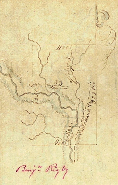
Roads and Traces in the Lake Creek SettlementClick Here To Read Lake Creek Settlement Narrative History Below is the map prepared by Elias R. Wightman and included with his English Field Notes for League Number 23 [Benjamin Rigby League]. North is shown by the pointer that looks like half of a fleur de lis. The map clearly shows a road that surveyor E. R. Wightman identifies as the Contraband Tra[ce]. Texas General Land Office File Number 6-438, English Field Notes, Benjamin Rigby League, Archives Record Program, Texas General Land Office, Austin. Close-Up of Wightman's Notation Identifyin Contraband Trace
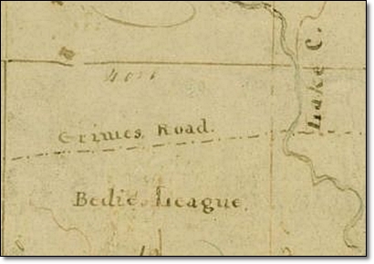
Texas General Land Office Shepperd’s store being located on the extreme west side of the John Corner League was located near what Austin Colony surveyor E. R. Wightman identified as the “Contraband Trace.” This trail ran north and south along the eastern side of the adjacent Benjamin Rigby League. [File Number 6-438, English Field Notes, Benjamin Rigby League, Archives Record Program, Texas General Land Office, Austin] According to the map accompanying the “English Field Notes” prepared by Surveyor E. R. Wightman for League No. 23 [Benjamin Rigby League] in 1831, the “Contraband Trace” is shown rising out of the northern portion of the Zachariah Landrum League and running along the eastern edge of the Benjamin Rigby League. Within a short distance to the south of Shepperd’s store, the Contraband Trace intersected two other trails that E. R. Wightman identified as the Coushatta Trace and the Grimes Road. Long before the arrival of Stephen F. Austin’s colonists, the Coushatta Indians had traveled through the lands that would become the Lake Creek Settlement upon the Coushatta Trace. According to Howard N. Martin, “The Coushatta Trace was a road from Louisiana into Texas that was used by the Coushatta Indians in their hunting and trading activities. It was an important middle road between the better-known and Spanish-patrolled Atascosito Road along the Texas coast and the Old San Antonio Road farther inland… Although the Coushatta Trace and the Atascosito Road were the most important roads through Austin's colony, the actual route of the Coushatta Trace has been discovered only generally and recently… In the area of present day Montgomery County the Coushatta Trace passed along the eastern side of the San Jacinto River, crossed this river near the Iron Mound league [Raleigh Rogers League], and turned west. It ran south of the site of present Montgomery and then passed through what is now Waller County to the Coushatta crossing of the Brazos River.” Howard N. Martin, “COUSHATTA TRACE,” Handbook of Texas Online (http://www.tshaonline.org/handbook/online/articles/exc05), accessed April 02, 2015. Uploaded on June 12, 2010. Published by the Texas State Historical Association.
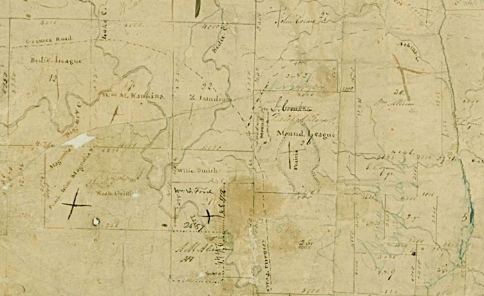
1831 - Surveys in Austin’s Colony along the west bank of the San Jacinto River Showing
Intersection of Coushatta Trace and Grimes Road in Lake Creek Settlement
Texas General Land Office
Map/Doc #: 79, Title: [Surveys in Austin’s Colony along the west bank of the San Jacinto River], Region: Austin’s Colony, Citation Date: [1831], Surveyor: [E. R. Wightman], Texas General Land Office, Austin, Texas.
According to the 1831 map of land grants along the west fork of the San Jacinto River in Austin’s Colony also
prepared by E. R. Wightman, a portion of the Coushatta Trace is labeled and shown running through five leagues
of land that would later be part of the Lake Creek Settlement. The Coushatta Trace runs north and south through
the Raleigh Rogers League [Iron Mound League] crosses over onto the Zachariah Landrum League and then back onto
the Raleigh Rogers League. The Coushatta Trace then turns east so that it runs east and west across the John
Corner League, the William Atkins League, and the William C. Clark League heading toward the west fork of the
San Jacinto River.
Grimes Road
Coshatta (Coushatta) Trace
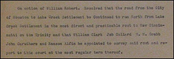
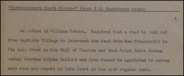
1837 Washington County Commissioners' Court April 3, 1837 1837 - Roads in the Lake Creek Settlement Following the Texas Revolution, the Lake Creek Settlement was located in Washington County until Montgomery County was created on December 14, 1837. The WPA (Works Progress Administration) transcribed the minutes of the Washington County Commissioners' Court from April 3, 1837 to January 7, 1846. These transcriptions can be found in the archives of the Dolph Briscoe Center for American History at the University of Texas in Austin, Texas. The original minutes of the Washington County Commissioners' Court from this period (Republic of Texas) are no longer located within the Washington County Clerk's Office so historians are very fortunate that the WPA preserved these records by transcribing them during the Great Depression.
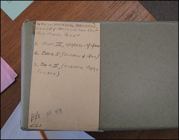
File Box 4E 418 - Dolph Briscoe Center for American History, University of Texas, Austin, Texas See File # 4E 418, "WPA Historical Records Survey - Washington Co. - Min. Comm. Court," 2. Book I, (Carbon & MSS).
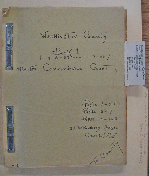
Washington County, Book 1 (4-3-[18]37 - 1-7-[18]46), Minutes Commissioners Court. The first meeting of the Washington County Commissioners' Court was held on April 3, 1837. Washington County, Texas was created in 1836 and was organized in 1837. See February 13, 1837 election returns above. The first Washington County Commissioners' Court meeting was held on Monday, April 3, 1837. Many references were made to the Lake Creek Settlement in the first nine pages of the minutes of the Washington County Commissioners' Court. At the first meeting on April 3, 1837, Justices of the Peace Jeremiah Worsham and George Galbraith represented the precinct of Lake Creek.
At this meeting, Justice of the Peace/Commissioner George Galbraith from the Precinct of Lake Creek made a motion to lay a road from the Lake Creek Settlement to the City of Houston.
Page 2
Sheet 2 of Page 2
See File # 4E 418, "WPA Historical Records Survey - Washington Co. - Min. Comm. Court," 2. Book I, (Carbon & MSS) located in the Dolph Briscoe Center for American History at the Unversity of Texas, Austin. Also see Washington County Texas Court of Commissioners of Roads & Revenue 1836-1846, originally transcribed by the WPA, 2001, GTT Books, Indexed by Pat Gordon 2002, pp. 1 & 2. 1837 Washington County Commissioners' Court April 4, 1837 The next day, April 4, 1837, Justice of the Peace/Commissioner William Robert from the Precinct of San Jacinto moved that the road from the Lake Creek Settlement to the City of Houston be continued north from the Lake Creek Settlement to the town of New Cincinnati.
Sheet 2 of Page 3
Page 4
See File # 4E 418, "WPA Historical Records Survey - Washington Co. - Min. Comm. Court," 2. Book I, (Carbon & MSS) located in the Dolph Briscoe Center for American History at the Unversity of Texas, Austin. Also see Washington County Texas Court of Commissioners of Roads & Revenue 1836-1846, originally transcribed by the WPA, 2001, GTT Books, Indexed by Pat Gordon 2002, pp. 1 & 2. It is important to note that a place called "Montgomery" does not appear in the Washington County Commissioners' Court Minutes for the first time until October of 1837, three months after the Town of Montgomery was founded. |

%20Trace%20on%201831%20Map%20410.jpg)
.jpg)

